Come late November, gamefishers around the country suddenly start taking interest in the computers that they have neglected over the winter months.
They start thinking about packing away the winter snapper fishing equipment, sharpening game fishing hooks, and planning for the season ahead.
Banter around game fishing club tables turns to where to fish… its all hinging on the warm water, and likley they’re following via satelite Sea Surface Temperature images (SST)
There are many factors that influence the arrival of the warm water. Ocean currents and wind being two of the most important.
We’ll take the current game fishing season as an example. During October and Novmeber, we had unusually settled weather, with just a few moderate Northerlies. This allowed the warm water to push in close earlier than expected. As a General rule, the first billfish of the season is cought somewhere around New Years Day, give or take a week. This year, marlin were hooked and dropped during the middle of December, at the same time water temperatures of 21 degrees were recorded at Schooner Rocks.
Then the Sou Westerlies hit.
This pushed the warm water out and to the east. Sea surface temperature charts showed a warm finger of water down the Kermadec trench. but it was unable to overcome the strong offshore winds. On the 19th of January, the water was 18 degrees on the surface at Motitti island, and at 26m where I was spear fishing Terakihi, the temperature was a bone chilling 16.5 degrees.
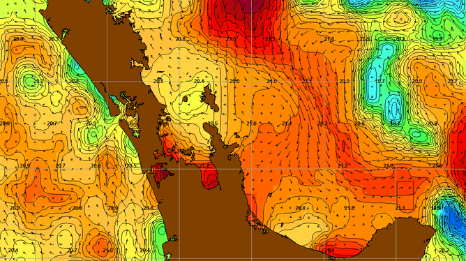
Since then, we have had a couple of sub tropical depressions hit the country and pass out to the east. The prevailing north and north-easterly winds and swell associated with these systems, matched the currents, and the warm water came back!
There are many platforms from which to follow the movements of the Temperature.
The metservice offers a service for the whole country. And is a good general indication of the water temps across the whole country. Its free, but not very specific.
Niwa offers a slightly better service, which is charged through a subscription service service. This gets updated weekdays, but not public holidays. Its a good general indication, but given that your SST could be up to 24 hours since it was last updated (or 72 if it was a weekend), and the current could be moving at a rate of 0.5-1kts, your patch of warm water could have moved by as much as 12NM (36nm on a long weekend!!).
Probably the easiest way to get SST information, Furuno’s Navnet TZ touch system can download it directly using a hotspot made by your smart phone. You can download it out at sea, and overlay it on your chart provided you have an internet signal. But again, the SST information isn’t 100% precise.
For the best accuracy, commercial systems such as Geoeye from Digital Globe, which will cost you US$500 per Month, or US$160 per week, are the only choice. The price can be a bit of a hurdle, but when compared to a tank of fuel (which you are likely to save) it soon becomes economic. With Geoeye, Clorophyll, currents, salinity, thermocline depths and the depths at various can also be tracked, giving you more information to make the all important catch
To put it into perspective, your monthly cost is equivalent to 400L of diesel. About two days trolling in an average boat.It can save you a lot of time looking for the all important temperature breaks.
Essentially that is what we as game fishermen are looking for. We are searching for places where the current changes dramatically, where the water colour changes suddenly, or where the temperature changes. if you get all three…well…give me a call and tell me where.
Its not all about finding the warmest patch of water. Its more about finding warm waterin proximity to baitfish. Which as a general rule tend to hang out in the cooler more nutrient rich waters.
Marlin and Tuna will chase food into cold water. I have personally seen striped marlin in water of 17.5 degrees, cold and green, off Whangaroa…. but they weren’t lightyears away from warm water.
The trick with Using a SST to your advantage, is actually to use many of them. Follow the general trends of the currents as they move the warm water around. Cross refernce it with places that are known to hold food (Pinnacles, canyons, harbour mouths etc) then, on the day you fish, take the latest data you can get your hands on and back it up with what you atre actually seeing on your temperature guages. Find the breaks, the bait, the colour changes.
At the end of the day, it is still fishing, and its not guaranteed that you’ll catch fish every time you go out. But by making the most of the information you have available, you can increase your chances of finding fish….then its just up to you to catch them.